Boggo Road Precinct -
Dutton Park Community Reclamation.
The Brief
|
Table Of Contents |
Table Of Figures |
1. Project Background
Boggo Road was built late in the 19th century and the early 20th century as a maximum security prison to incarcerate those judged and sentenced by the State. First constructed was the original Women’s Prison, now known as Division 2, then Division 1 the Male Brisbane, on the crest of the site; and finally the Female Prison at the rear of the site along the railway line.
Why Dutton Park was chosen is uncertain, however its selection was possibly due to Dutton Park being perceived, at that time, as well out of town. Set high on the hill it provided a location where those convicted could be locked away from sight – detained until a time when the State saw it was suitable for them to be integrated back into the community.
Boggo Road Gaol was like a festering sore for the community of Dutton Park. Dark sombre brick walls lined with razor wire hiding the ugliness of life within from those without. This presented a harsh façade to the local residents. What would it have been like going about life in the houses in Lochaber Street Dutton Park, on the hill overlooking the prison, knowing that there was no escape from the brutality of a life of confinement for those inside the gaol? How would the children of Dutton Park Primary School felt walking past and looking up to see the guards patrolling the perimeter?
How does a community cope with a maximum security gaol as part of its urban landscape? Most probably by ignoring it. The site and its prison would have become invisible to the surrounding community. While there was no view from within the prison to the outside, similarly, from outside, the walls of the prison and everything it stood for would have been muted, even expunged, from the community’s collective consciousness.
As part of reforms within the criminal justice system the Boggo Road Gaol has been closed forever – no longer will anyone be subjected to the inhumane conditions for which this prison was known.
Just as is now accepted that prisoners need to be re-integrated with the community, the Gaol itself must now be rehabilitated for community use. The question arises, what built forms could heal the scar which left by, at times, cruel and brutal confinement, that has been the defining feature of this site for almost a century?
To better assess the exact form of rehabilitation required, a brief study of the suburban and community profile of Dutton Park, abstracted and excerpted from the Brisbane City Council’s “Ward of Dutton Park”, follows.
2. Suburban Community Profile
2.1 Local History
The area covered by Dutton Park Ward was originally inhabited by the Jagera people, who occupied much of the area now covered by the southern suburbs of Brisbane. The ward contained a number of camping places along the river, as well as two bora rings. With the arrival of Europeans, both these sites were lost and a temporary bora ring was established in what is now Musgrave Park. The park retains a special Significance for Aboriginal people.
Boundary Street in West End is also of particular significance to Aboriginal people, as this was the curfew boundary. Aboriginal people were not allowed in the inner-city area after dark.
The first European settlers were fruit growers and market gardeners. After 1860 the area became urbanised, first with town houses built by squatters from the Brisbane hinterland and the Darling Downs, and later with smaller, more closely built houses.
The South Coast Railway was opened in the 1880s, and ran through South Brisbane, Dutton Park, Fairfield and Yeronga. From 1898 to 1915, the tramlines were also gradually extended along Annerley and Ipswich Roads. Urban development tended to follow the progress of these transport routes fairly closely, and then to gradually fill in the areas between. Much of the southern part of the ward was closely settled by the start of the Second World War.
Industrial development came later, with the Peters Ice Cream Factory built in 1929 and Tristram's in 1931. Other industries followed, including transport, engineering, paint manufacturing and welding plants.
2.2 Overview Of The Community
Dutton Park Ward contains two broad geographical areas. The northern part consists of the suburbs of West End, Highgate Hill and Dutton Park, and parts of South Brisbane and Woolloongabba. The southern part includes the suburbs of Fairfield and Yeronga, and parts of Annerley and Yeerongpilly that are the subject of the Stephens District Local Area Plan. The Brisbane River is the major geographical feature of the ward and forms the northern and western boundaries. The ward extends east to the South-East Freeway and south as far as Moolabin Creek and Cracknell Road, Tarragindi. The major transport routes through the ward are the railway lines and Annerley and Ipswich Roads. These act as physical barriers to the communities living on either side.
The area’s historical development has resulted in the close proximity of residential, industrial, commercial and retail land uses. There is also a mix of housing in terms of age, density, style and value. The major industrial areas are west of Montague Road in West End, and along Hyde Road in Yeronga. Industries include manufacturing, food processing, medical laboratories, vehicle maintenance, warehousing and commercial distribution. Research for the West End Development Control Plan revealed that the vacancy rate for industrial and warehouse space was over 50%.
The ward contains two major shopping complexes, at Cornwall Street, Buranda and Fairfield Gardens at Fairfield, and strip shopping centres on Boundary Street, West End and Annerley Junction, and in Woolloongabba. The development of larger shopping complexes has contributed to a change in the character of local and neighbourhood shopping centres. Some, such as Annerley Junction and Woolloongabba, now feature thrift shops and budget retail outlets while others, such as West End, are developing their cosmopolitan culture through new commercial ventures.
The northern part of the ward has been quick to embrace the new opportunities in outdoor dining that have resulted from recent changes to health regulations, and is rapidly building a reputation for its range of restaurants and coffee shops. There are now almost 200 cafes, restaurants and other food outlets in Dutton Park Ward. This change is not without cost, however, as many of the cheaper retail outlets are converted to more expensive businesses.
In the southern part of the ward, the shopping centres at Annerley Junction and Chardon’s Corner have been adversely affected by increased traffic along Ipswich Road. The Stephens District Local Area Plan has highlighted the need to revitalise these centres and consider safety issues and the provision of amenities.
The northern part of the ward is well provided with health, education, welfare, child-care, sport and recreation, parks, cultural and community development services. This wealth of resources and proximity to the Central Business District has made this an attractive residential location and, as in many inner-city areas, gentrification is occurring. The challenge is to maintain the cultural and social diversity, and housing affordability, that have long been features of this area, while embracing the opportunities presented by redevelopment.
The southern part of the ward has good access to medical and educational facilities, but less in the way of welfare and child-care services, cultural activities and community meeting places. These issues have also been addressed in the Local Area Plan for the Stephens District.
All parts of the ward are characterised by great social diversity. In the northern part of the ward, the presence of a number of boarding houses, hostels and tenements adds to the residential diversity.
2.3 Demographic Analysis
This section provides an outline of the demographic characteristics of the ward. The information is drawn primarily from the Australian Bureau of Statistics (ABS) 1991 Census of Population and Housing. Two other statistical sources have been used to provide a more up-to-date picture and add to our understanding. These are the ABS Estimated Resident Population 1994 figures and 1994 June Quarter unemployment data available from the Commonwealth Department of Employment, Education and Training (DEET). Both are estimates only, and are only for those Statistical Local Areas (SLAs) that lie completely or predominately within the ward, rather than the whole ward population. They should not he directly compared with the census information.
The aim in using Census statistics has been to provide as accurate a statistical picture of this ward as possible. The Australian Bureau of Statistics collects information within Statistical Local Areas (SLAs). These largely coincide with single suburbs, although they sometimes contain more than one. The terms ’suburb’ and ’SLA’ are used interchangeably for the sake of simplicity.
The Statistical Local Areas of Annerley, Yeerongpilly, Woolloongabba and South Brisbane are only partly within Dutton Park Ward. Figures quoted for these suburbs are for that portion rather than for the whole suburb.
Only the salient demographic features of the ward have been highlighted here. The more detailed statistical tables on which this profile is based are contained in the Appendix.
2.3.1 Population
The population of Dutton Park Ward was 33 763 at the 1991 Census which represents 4.5% of Brisbane’s total. The suburbs with the largest populations were Annerley (7085), West End (5 994), Highgate Hill (5 047) and Yeronga (4 501).
Moderate growth occurred in Annerley (4%) and Yeerongpilly (3.4%) but quite dramatic population decline in the suburb of Dutton Park (-8.5%). South Brisbane, West End and Woolloongabba all declined by 3 to 4%. This contrasts with an average population increase for Brisbane of 5.1%.
2.3.2 Age Distribution
.jpg)
Figure 1 shows the age distribution compared with Brisbane as a whole. Dutton Park Ward has a broadly similar age distribution to the rest of the city. However, there are slightly higher proportions of people over 65 years (15.8%) and correspondingly fewer children under 15 years (14.1%o).
This pattern holds true for individual suburbs within the ward; however there are some variations. Compared with the ward as a whole, Woolloongabba has an older age profile, while Yeerongpilly has a higher proportion of children under 15.
2.3.3 Birthplace, Aboriginality, And Language
Dutton Park Ward has an ethnically diverse population. In 1991, 22.1% of the population had been born in a non-English-speaking overseas country, double the proportion for Brisbane as a whole. There are high concentrations of people from non-English-speaking countries in West End (0.8% of the population), Highgate Hill (22.4%), Woolloongabba (21%), South Brisbane (21.1%), Dutton Park (19.5%) and Annerley (15.5%).
Of particular note is the large Vietnamese-speaking community in West End, which accounts for 8% of the population of that suburb. The ward also has a large Greek-speaking community, making up 16.1% of the population of West End, 14.4% of Highgate Hill and 8.4%o of Dutton Park.
The ward also contains a significant Aboriginal and Torres Strait Islander population, almost 500 in total, most of whom live in the suburbs of West End, Highgate Hill, Dutton Park, Woolloongabba and South Brisbane. It should be noted that in view of the large number of homeless persons in this community, the true Aboriginal and Torres Strait Islander population may be much larger.
2.3.4 Households And Families
Figure 2 shows the proportion of different types of households in Dutton Park Ward compared with Brisbane. The pattern of household structure in the ward differs markedly from that in Brisbane. There is a much lower proportion of family households, 52.1% compared with 70.2%. Correspondingly, the figures for lone-person households (55.7%) and group households (12.2%) are greater than the Brisbane totals of 23% and 6.8% respectively.
.jpg)
This pattern is found in all suburbs, but group and lone-person households are most common in the northern part of the ward, especially in South Brisbane (40.8%), Dutton Park (40.7%), Highgate Hill (39.6%), West End (37.3%) and Woolloongabba (36.3%).
This pattern coincides with other distinctive features of the ward, including the older population in Woolloongabba and the high concentrations of unit, apartment and privately rented housing in the north.
Figure 3 shows the proportion of various family types within Dutton Park Ward compared with Brisbane as a whole. The statistics reveal a marked difference from Brisbane, particularly in the northern part of the ward. Specifically, there are larger proportions of sole-parent families (17.6%) and couples without children (37.2%), compared with the Brisbane averages of 14.6% and 32.9%. Correspondingly, there are fewer two-parent families, 40.2% compared with 49.7%. This pattern is particularly evident in Dutton Park, Highgate Hill, Woolloongabba, South Brisbane and Annerley.
.jpg)
2.3.5 Annual Family Income
Compared with Brisbane as a whole, Dutton Park Ward has a high concentration of low-income families. 4.8% of families have annual incomes below $12 000, compared with the Brisbane total of 3.4%. 25.5% of families earn between $12 001 and $25 000, compared with 21.7% for Brisbane as a whole. There is also a lower proportion of families with annual incomes over $60 000 (12.6%) than the Brisbane average (16.1%).
The suburbs of Dutton Park, South Brisbane, Highgate Hill and West End all have high proportions of families with incomes below $12 000 per year. All suburbs except Yeerongpilly, Yeronga and South Brisbane have a higher concentration of families with incomes between $12 000 and $25 000 than Brisbane as a whole. By contrast, Fairfield, Yeerongpilly, Yeronga and Annerley have higher concentrations of people in the $40,001 - $60 000 range than the Brisbane average.
2.3.6 Housing
Dutton Park Ward has a significantly higher proportion of flats and apartments (43.3%) than the Brisbane total (17.2Zo), and a lower proportion of detached houses (53.8%). Fairfield (79.9%) and Yeronga (71.5%) are the only suburbs within the ward that have proportions of detached houses similar to the Brisbane total of 78.7%. Suburbs in the northern part of the ward have a particularly high concentration of flats and apartments, which comprise more than 50% of housing in South Brisbane, Highgate Hill and West End.
Given the nature of the housing stock, it is not surprising that most of the ward has comparatively low levels of home ownership. In Dutton Park Ward, 41.6% of housing is available for private rental, considerably more than the Brisbane total of 23%. More than 50% of the housing in South Brisbane and Highgate Hill, and more than 40% in West End and Annerley, is rented privately.
There is also a significant proportion of public housing in the ward, 6.6% compared with the Brisbane total of 4.9%. This is mainly in Dutton Park (19.4% of all housing), Yeerongpilly (14.8%) and Woolloongabba (10.2%). This housing is predominantly medium-density units, much of it built in the last ten years. Despite this concentration of public housing, waiting lists and waiting times are much longer than those for more outlying parts of Brisbane, as many people prefer to live in the inner city.
The proportions of home ownership (31. 5%) and of homes being purchased (13.8%) are significantly lower than the Brisbane averages of 41.7% and 23.7%. However, the figures for Yeronga and Fairfield are very similar to the Brisbane averages.
2.3.7 Employment And Unemployment
At the time of the 1991 Census, unemployment rates were much higher in the ward than those in Brisbane as a whole. The unemployment rate in West End and Dutton Park was over 20%, and over 15% in South Brisbane, Woolloongabba and Highgate Hill.
This ward has a slightly lower labour force participation rate that Brisbane as a whole, with 60.8% compared with 62.3% for Brisbane. Labour force participation rates measure the proportion of people 15 years and over who are either employed or actively seeking employment. The suburbs of Woolloongabba (44.7%) and South Brisbane (54.7%) have particularly low participation rates for both men and women. Yeronga and Yeerongpilly have relatively high participation rates for men.
The level of unemployment in the ward is 15.6%, which is significantly higher than the figure for Brisbane (8%). South Brisbane (20%), Dutton Park (18.4%) and West End (17.9%)) have significantly higher rates of unemployment, while the rates for Yeronga and Yeerongpilly are comparable with Brisbane averages.
2.3.8 Motor Vehicle Ownership
There is a significantly lower level of motor vehicle ownership in this ward than in Brisbane as a whole. While the percentage of households with one motor vehicle is comparable with the Brisbane average, the proportion of households with two (20.1%) and three or more vehicles (6.4%) is significantly less than the Brisbane averages of 29.7% and 11.1% respectively.
Of particular note is the large proportion of households without a vehicle (27.1%) that is almost double the Brisbane figure of 15.2%. The proportion of households without a vehicle is highest in the northern part of the ward, particularly Dutton Park (7.2%), South Brisbane (36%) and West End (33.7%), which are well serviced by public transport and have a large number of multiple dwellings.
2.3.9 Demographic Summary
Dutton Park Ward is a socially and ethnically diverse area. The northern part of the ward reflects the developing character of the inner-city suburbs, with increasing numbers of flats, apartments and houses available for private rental. Higher income professional people co-exist within suburbs that generally have below-average family income and high rates of unemployment. The northern suburbs house higher proportions of older people, but also have a significant representation of young adults living alone or in groups. There are also greater proportions of one-parent families and significant concentrations of public housing. There are distinctive pockets of immigrants from Vietnam and Greece, and a significant Aboriginal and Torres Strait Islander community. A feature of the ward is the high proportion of households with no motor vehicle. By contrast, the demographic profile for the southern part of the ward more closely reflects the Brisbane averages in terms of family type, annual family income and age structure.
2.4 Social And Community Infrastructure
The following section addresses both community strengths and needs and is not intended to he a detailed blueprint for future action. It relates to important facilities and services that are often the shared responsibility of Brisbane City Council and the State or Commonwealth governments. The section therefore provides information that will be of use to the community generally and to the three levels of government.
2.4.1 Community Services And Health
Dutton Park Ward is the site of a number of city and state wide services and organisations. These include the Musgrave Park Aboriginal Corporation, the Aboriginal and Torres Strait Islander Corporation for Women, the Ethnic Communities Council of Queensland and the Brisbane Migrant Resource Centre.
The northern part of the ward has also been a centre of intense, and often innovative, local community development activity. A strong sense of place and community identity, coupled with skilled residents, has led to community ventures in relation to housing, employment and community support services. West End Community House, a very well established community centre, actively supports these activities. The St. Vincent de Paul Hostel at South Brisbane, and the Musgrave Park Aboriginal Corporation, cater for the large homeless population in the ward.
Various church and community organisations offer a range of services in the southern part of the ward, including Compass, Mary Immaculate Employment Group, and the Queensland Blind Association. The Department of Social Security office is in Annerley. These services are not well coordinated, and Local Area Plan consultations with residents have revealed concern over the need for community meeting places and networks. The recently established Community Centre in a Council owned building at Waldheim Street, Annerley, aims to respond to these concerns.
There are three Council libraries, in Annerley, West End and Fairfield. The West End library holds the distinction of being the first purpose-built library in Queensland, built in 1928. It is one of Council’s Languages Other Than English (LOTE) libraries, specialising in Vietnamese and Greek. The library attracts borrowers of all ages but has limited opening hours.
The Annerley library is located at Annerley Junction and has been the base for the southern Home Library Service, which will soon be relocated to the Holland Park library. The most recently constructed library, at Fairfield Gardens, is next to the Ward Office and has a meeting room that is well used by community groups.
Education and child-care facilities are generally readily available except for occasional care. There is a particular emphasis on culturally appropriate services, such as the Aboriginal and Islander Independent Community School in West End. There are eight primary schools, as well as a school for visually handicapped children and a special school. Many students attending the five secondary schools in the ward come from other parts of Brisbane, and travel into the area on public transport.
The ward also contains the Brisbane Dance School of Excellence, the Open Learning Centre Network, Queensland Distance Education College and a range of resource and support services for both the state and catholic education systems. Yeronga TAFE College is the only tertiary institution within the ward, but the University of Queensland, Queensland University of Technology and South Bank TAFE College are close by.
Dutton Park Ward has one of the greatest concentrations of medical facilities in Brisbane. There are three large hospital complexes – Mater Public, Mater Private and Princess Alexandra – which provide services to patients from all over Queensland. There is also a range of specialist health services, seven-day medical centres, and services catering for specific groups such as people from non-English-speaking backgrounds, Aboriginal and Torres Strait Islander people, people with disabilities, and the gay and lesbian communities.
There is a cluster of services for people with vision and hearing impairments in the area between Stones Corner and Annerley. The ward also has a dental health program and a number of community-based health services, including a child health centre in West End. This centre operates one day each week, and conducts general health clinics catering for children from birth to four years of age. Clinics are also conducted at selected day care centres and primary schools. The Blue Nursing Service complex on Thomas Street, West End provides community care, domiciliary services, a continence clinic, and has a day respite and residential centre.
The ward is well served by public utilities such as police, fire services and the State Emergency Service. Most of the ward is served by the ambulance centre in South Brisbane.
The availability of low-cost housing, a good system of public transport and a range of support services, have attracted people with specific needs. For example, anecdotal evidence suggests that an increasing number of people with psychiatric disabilities are now living in this area. The presence of these extremely disadvantaged people has prompted some innovative community-based responses, which provide support and build links between people with disabilities and the surrounding community.
Council immunisation clinics are available in Moorooka and Coorparoo. Annerley Community Health, a State Government initiative, provides a range of services including counselling, therapies and outreach services for aged and disabled people. Access is not easy for people with disabilities, and relocation (possibly outside the ward), has been discussed.
This is a hilly area with many high-set homes, which presents difficulties for older people. The presence of an ageing population highlights the need for support services to maintain these people in their own homes. Other health and safety issues in this ward include pedestrian safety, air and noise pollution on major roads carrying high volumes of traffic, and the close proximity of industrial and residential areas.
2.4.2 Transport
In general, the ward is well serviced by public transport. Railway lines serve the suburbs of Yeerongpilly, Yeronga, Fairfield, Dutton Park and South Brisbane. A large number of bus routes pass through this area on the way to the city.
West End, Highgate Hill, South Brisbane and Dutton Park are also served by Brisbane’s first Hail and Ride bus service, which provides a continuous service within these suburbs. This service has significantly increased the mobility of older people and those without access to a private vehicle.
Ferries link the University of Queensland to Dutton Park and West End. Brisbane Transport’s High Speed Ferry Strategy will see a ferry service operating between Hamilton, the CBD and St. Lucia in 1996.
The main issue raised by residents is the need for more local transport links, particularly between suburbs in the southern part of the ward (Annerley, Fairfield, Yeronga and Yeerongpilly),
The Brisbane Transport Network Review is currently examining the need for additional bus services across the city. The Review is focusing on the demand for after hours and weekend services, the feasibility of feeder services to bus and rail interchanges, and on opportunities for expanding daytime services. Implementation of the recommendations of the Review is due for completion in 1997.
The standard gauge railway line from the Port of Brisbane to the National Rail Freight Terminal at Acacia Ridge also runs through this ward.
A number of arterial roads pass through the ward, including Ipswich, Fairfield, Annerley, and Gladstone Roads, and Vulture Street, which are some of the busiest roads in Brisbane. The South-East Freeway runs along the eastern edge of the ward.
Traffic to and from major facilities such as South Bank Parklands and the Brisbane Convention and Exhibition Centre, as well as that associated with the industrial areas of West End, has contributed to high traffic flow in the residential areas of Highgate Hill and West End.
The South East Freeway Bikeway runs along the eastern edge of the ward, and takes the rider through bushland, parks, quiet residential streets and sporting fields. This bikeway links with the South Bank Boardwalk Bikeway and the Riverside Drive Bikeway in South Brisbane and West End. Another important system of bikeways runs from the Brisbane Corso at Yeronga through Goodwin, Fehlherg and Yeronga Parks. It links to riverside bikeways in Fairfield and Dutton Park, and bike routes (signposted streets shared by bicycles and motor vehicles) that run across the ward and merge with the Norman Creek Bikeway.
Key traffic issues for local residents are the noise and volume of traffic on the major roads; the difficulty of pedestrian access in an environment of heavy traffic; and ”rat running” (the intrusion of through traffic into residential streets). Particular concerns have been raised about the safety of crossing Ipswich and Annerley Roads, especially for older people and those with disabilities. Traffic calming has been undertaken in parts of West End, Yeronga and Annerley to discourage ”rat running” and to restrict truck access.
2.4.3 Cultural Development
The northern part of the ward has a rich concentration of cultural services and facilities centred around West End. It contains a number of cultural organisations such as the Queensland Community Arts Network and Street Arts Community Theatre Company, as well as ethnic and Aboriginal services which have a strong cultural and arts focus. Some organisations have specific arts workers who are able to link with the informal social and cultural infrastructure that is a key strength of this community.
There are fewer cultural organisations in the southern part of the ward, apart from St. Luke’s Theatre Group based at Ekibin Road, Annerley. Consultations for the Stephens District Local Area Plan have revealed a number of people in this part of the ward who are active in the field of cultural development, and who are keen to see greater local activity,
The ward is home to a group of community arts practitioners who are very active in the community. The availability of low-cost accommodation, a good support network and gallery space has also attracted young artists to the area. The Richard Randall Studio and the Jagera Community Arts Resources Centre, which are available to community groups and emerging artists, are in this ward. There is a need for additional workshop space for community-based projects. Discussions are under way to increase community access to performance facilities in local schools.
The Brisbane Migrant Resource Centre in West End is an important facility (available at little or no cost) for community based activities, performances, workshops and meetings. This space is in constant demand. West End was the site of Brisbane’s first mural project, and is now the site of a Streetscape project on Boundary Street that is funded by Brisbane City Council and the Australia Council. Other significant cultural facilities are Emma’s Bookshop (which is the centre of a well developed community and cultural network), Yeronga High School Cultural Centre, and the Princess Theatre.
Friends of Yeronga Park are an active group of residents in the southern part of the ward with interests in the environment, urban development and cultural issues. The ward hosts several Wide-wide festivals such as Fiesta and Panegyric in Musgrave Park, and the Winter Solstice Festival in Davies Park, West End. Adding to the general amenities is the ward’s proximity to the city, the Queensland Cultural Centre and South Bank Parklands in South Brisbane.
There is concern that widespread redevelopment and new project, such as the Brisbane Convention and Exhibition Centre, will result in a loss of affordable housing and change the community and cultural infrastructure. Some artists have already relocated to Fairfield and Annerley because of this.
Recent storm damage to the Rialto Theatre in West End has raised questions about its future. A community action group is lobbying to save this important cultural facility. The Boomerang Theatre in Annerley has recently been demolished.
2.4.4 Sport And Recreation
The ward has facilities for tennis, hockey, bowls, croquet, cricket and four codes of football. It also has two Council swimming pools, at Yeronga and West End, which are heavily used. There are scout huts at Yeronga and Annerley, and a large commercial martial arts facility at Annerley.
Community access to the riverfront is complemented by walking and bicycling tracks, and parkland with family recreation areas. Access to sports on the Brisbane River, such as rowing and sailing, could increase public participation in these sports.
Organised sporting facilities are supplemented by recreational amenities such as the basketball half court for young people in Dutton Park. Another half court will be built in 1996.
Sporting and recreational pursuits reflect cultural diversity. Some sporting groups have combined to make year-round use of facilities. A number of the larger sporting clubs have employed development officers to work in schools and with their junior teams.
The Blind Cricketers’ Group at Yeronga is a good example of a community group catering for people with disabilities.
2.4.5 Parks And Open Space
There are 38 parks and bushland areas in Dutton Park Ward covering 131 hectares. In general, the ward has a good supply of parkland and open space, particularly along the riverfront and in Yeronga and Fairfield. This is largely because these areas were seen as unsuitable for housing due to the risk of flooding.
South Brisbane’s riverside parks offer opportunities to walk or cycle along the river’s edge, or watch rowers from one of three rowing clubs located here. Upstream from Davies Park there is a public jetty, opposite the historic Davies Park Shot Tower. A boat ramp is soon to be constructed on this site.
Orleigh Park in West End is a very popular riverside park. It has large mature trees, picnic and play facilities, and easy access to the cross-river ferry. Some riverside parks are popular gathering places for young people, and there are sometimes conflicts with other park users.
Musgrave Park, in South Brisbane, is an important heritage park. As well as being a site of cultural significance for Aboriginal people, it is the only accessible parkland available to many people living in high and medium-density housing. Musgrave Park contains a swimming pool, several areas leased by sporting, recreational and community groups, and is also a popular festival site. It will be the subject of planning work by Council in the next two years.
Yeronga Park is significant because of its location, size, range of uses and history. It is a large park alongside a primary school, a secondary school, and Yeronga TAFE College. Bikeways link it to other nearby parks. Yeronga Park features an Anzac memorial, ornate entry gates and a fig-lined Memorial Avenue. It also contains an area of natural habitat, a heated swimming pool, tennis courts and a sports oval. A number of sites are leased by sporting, recreational and community groups. This park will also be the subject of planning work by Council throughout 1996, aimed at the development of an integrated plan for its future use.
Many of the parks in Yeronga and Fairfield are large and have facilities such as bikeways, paths, toilets, play equipment, shade structures and barbecues. Several parks along the main roads in Yeronga and Fairfield are also fenced. A great deal of tree planting has been undertaken in this area in the last 10 years.
3. The Site
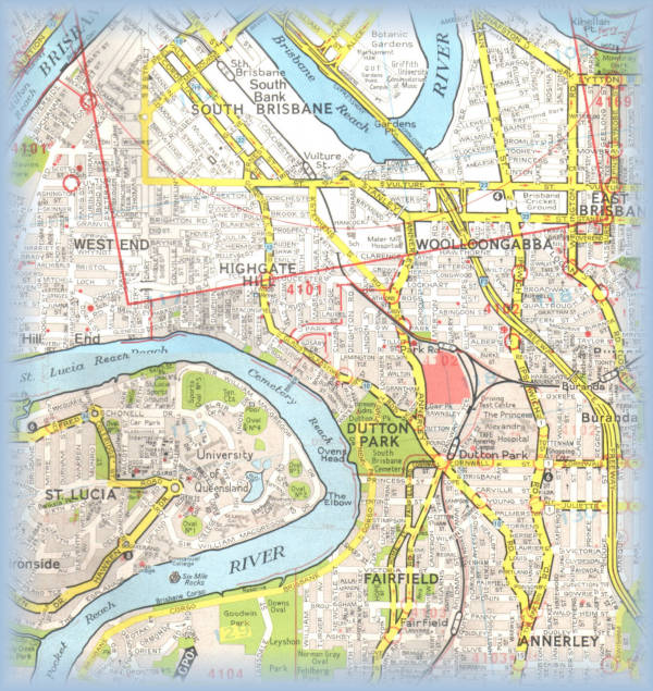
The site is 9.5 hectares and is located on Annerley Road Dutton. It comprises of the following lots:
6 Lot 205 SL 809188
6 Lot 206 SL 809188
6 Lot 207 SL 809188
6 Lot 208 SL 809188
6 Lot 307 CP886793
6 Lot 16 CP 885454
It is bounded to the north by the Dutton Park Primary School, the east by passenger and freight rail lines, the south is adjacent residential allotments and the west boundary is contained by Annerley Road.
The site is located within four kilometres of the Brisbane CBD and the Ward of Dutton Park, as discussed in the Suburb and Community Profile, has the greatest concentration of medical facilities in Brisbane. There are three large hospital complexes – Mater Public, Mater Private and Princess Alexander – which provide services to patients all over Queensland. There is also a range of specialist health services and seven day medical centres.
4. Proposed Master Plan
The proposal for the Boggo Road Community Reclamation Scheme is to provide a means to integrate this key site back into the community of Dutton Park. The site will no longer be segregated from the suburb but become a focal node within the community.
It will provide Dutton Park with a centre, putting a soul back into the core of this geographically and socially segregated urban landscape. The development is to incorporate a mixed-use philosophy which will be both socially and financially self-supporting.
Underpinning the scheme will be a residential foundation of medium to high density that will provide both permanent and temporary accommodation. The proximity to the CBD and available transport infrastructure suggest that, to maximise the site’s potential, the urban density should be increased from the surrounding low density housing.
It is envisaged that the housing will be targeted at low to medium income levels and cater to a diverse range of demographics. Typical residents within an apartment building may include:
6 Single nurses working at the hospital
6 Young married couples with two or more small children
6 The self-employed working from the (family) home
6 Young medical professionals employed at the nearby hospitals
To create a focal meeting point for the community a “main street” will be developed within the scheme. Centred around the heritage listed Women’s Prison this will be the community heart with a range of restaurants, cafes, bars and retail services visible at ground level. The buildings within the ”main street” will also incorporate a vertical mixed-use of commercial and residential.
The site provides a pivotal link for the medical corridor connecting Mater Private, Mater Public and the Princess Alexander hospitals. The Boggo Road Reclamation Scheme will create a node for the medical precinct. This will be achieved by creating a physical, pedestrian and vehicular link from the site to the Princess Alexandra Hospital as well as accommodating a commercial component zoned for medical support services. Such services may include chiropractry , pathology, physiotherapy, medical imaging, and other peripheral medical services.
It is envisaged that this medical precinct will, in future years, extend along Annerley Road to provide a permanent commercial link between these hospitals.
The development will incorporate a mixed use philosophy which will provide both social and financial support to ensure its success.
5. Urban Pattern
The urban pattern of the Boggo Road Reclamation Scheme is based on Jeremy Bentham’s theories of panopticism that incorporate philosophies of observation and visual connection. To this end the scheme has at its centre a place of power, in this case the remaining Division 2 Gaol and its attached Division 1 remnant, from which all things radiate.
The centre of power will be sheathed by a retail and commercial precinct which will surround the heritage listed Prison – respecting the cultural and social significance it represents. From this core the urban pattern will radiate to the outer extremities of the site and provide a permeable connection to the immediately adjacent sites, as well as drawing from beyond the immediacy of the site to the adjacent residential areas.
While the scheme is shown illustrated by a literal radial urban pattern this may not necessarily be the final translation of the intent.
The regular pattern of scheme will create a strong legibility and sense of place. The standard allotment size within the scheme closely resembles the 10 x 40 metre allotments which are the genetic foundation on which Brisbane’s suburbs were built on. This has been altered slightly in recognition of the need to create allotments which provide more privacy from adjoining neighbours whilst limiting large areas of unused backyards.
These allotments will be amalgamated as required to create residential enclaves of medium to high density.
6. Existing Buildings
In recognition of the significance of the already built form in existence on the site the following buildings will be retained:
6.1 Division 2 - The Original Women’s Prison
The heritage listed Women’s Prison built in 1901 will be maintained. It is to be offered to Arts Council of Queensland for their exclusive use. Part of offering such a leasehold is that the heritage integrity of the building be maintained with no significance alterations.
Attached to the Division 2 building is a remnant of the Division 1 Male Prison, the remainder of which has recently been demolished. This remnant is also heritage listed. Design proposals for this site must incorporate and include this remnant, in an appropriate, creative and stimulating way.
6.2 Female Prison
The female prison that is located along the eastern boundary of the site. The core of this building will be maintained but the built form will be altered to reflect the current urban theories on residential communities.
Life in prison never allowed the luxury of connecting to anywhere, as a form of rectification of the one of the many wrongs of the Boggo Road Gaol, there will be philosophical link, which maybe expressed as either a visual or physical connection between the Division 2 heritage listed prison and the female prison.
6.3 Police Station
The police station on Annerley Road has a social significance to the community and will be maintained.
6.4 The State Archives
The building which houses the State Archives will be maintained within the development but the occupant is still to be determined.
7. Residential Requirements
The residential component of the development is to provide a diverse range of dwelling types to suite the diverse range of residents.
As previously mentioned, there are to be no single detached dwellings within this site as that would not represent the best site utilisation considering the site’s proximity to the CBD, hospitals and transport infrastructure.
All residential components will be medium to high in density and offer a range of options to suite varying demographic requirements. The residential developments will require integration with both retail and commercial precincts and the adjacent low density dwellings, requiring both a horizontal and vertical blending
8. Retail and Commercial Requirements
Located within the “main street” of the scheme, the retail and commercial precinct will directly address the heritage listed Division 2 Prison. It will provide built form which would cater to a range of tenancy size.
All tenancies (particularly those on the ground floor) must be designed so that they respect the significance of the heritage prison to the development. This maybe done in a manner of different methods of architectural expression depending on the location of the building with respect to the gaol.
As the retail/commercial precinct is directly adjacent to residential area it must have a form sympathetically integrates the retail, commercial and commercial developments.
9. Design Brief
The particular site within the Master Plan that this brief addresses is shown in Section 4, above.
The Site is of 1500 and positioned at place of primary importance to the fulfilment of the intentions of the Master Plan Concept. This importance derives from two main factors. Firstly, that site is at the major intersection scheme at which the hospital overpass meets the Retail/ Public Concourse and secondly that the site faces and must adequately address the Division 1 remnant, its surrounding plaza and the Division 2 Prison immediately beyond.
As noted above, design proposals for this site must incorporate or otherwise include this remnant, in an appropriate, creative and stimulating way. The height of development on the Site may not exceed that of the remnant excepting upon special dispensation.
The Site is to be developed so as to manifest and augment the underlying concepts of the Master Plan as outlined above and will include as a minimum;
6 600 m2 of Retail accommodation to be comprised primarily shopfronts facing the Public Concourse. Spaces provided should be allow a diversity of retail operations and allowance subdivision and amalgamation if necessary. The level of appointment is to be of a medium standard.
6 800 m2 of Commercial accommodation. The inclination toward medical services manifested in the Master Plan should be respected and facilitated. The level of appointment is to be of a high standard.
6 3000 m2 of Residential accommodation. This should take the form of a tower/podium arrangement, bearing in mind the height ceiling outlined above, and incorporate a range of residential quarters including, at a minimum, one and two bedroom units. The level of appointment may be mixed.
6 Parking in accordance with the town plan requirements.
This Site is ideally positioned within the Master Plan so as to become a bustling focal point of public interest. Developments proposed for the Site should actively seek to engage and sustain that interest.